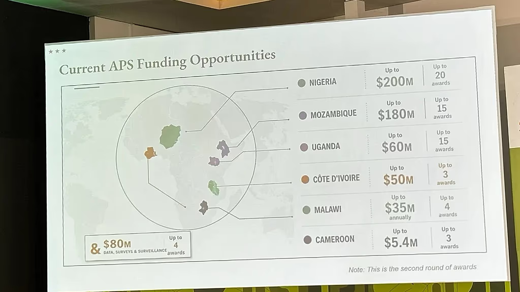
A U.S. State Department presentation at a major global health conference has sparked criticism after an AI-generated map of Africa wrongly labelled every country on the continent.
The mistake happened during the AIDS 2026 Conference in Rio de Janeiro, Brazil, where U.S. officials were presenting new global health partnership plans. Instead of focusing on the announcement, many attendees turned their attention to the inaccurate map, taking screenshots that quickly spread across social media.
A review of the presentation found the map carried an artificial intelligence watermark indicating it had been created using OpenAI tools. Reuters, which first reported the incident, said the company did not respond to a request for comment.
Among the most striking errors, Nigeria was shown as a landlocked country deep in the Sahara Desert despite being on West Africa’s Atlantic coast. Mozambique was moved from southeastern Africa to the Horn of Africa, while Ivory Coast appeared on the opposite side of the continent.
The State Department acknowledged the error and accepted responsibility.
In a statement, it said the incorrect map had been added after a last-minute change to the presentation by a member of the team. The department apologised for the confusion and said it regretted the misrepresentation, particularly to African delegates attending the conference.
The presentation was delivered by Jeff Graham, the senior U.S. official overseeing the President’s Emergency Plan for AIDS Relief (PEPFAR), Washington’s flagship global HIV/AIDS programme.
Despite the controversy, the State Department insisted the conference discussions remained productive and reaffirmed its commitment to supporting global efforts to combat HIV/AIDS.
The incident nevertheless reignited debate over the growing use of artificial intelligence in official government communications and the need for human oversight before AI-generated content is used in high-profile international events.
The mistake also drew sharp criticism online.
Emily Bass, an AIDS expert, first highlighted screenshots of the presentation, while several posts on LinkedIn attracted tens of thousands of views.
Matt Petit, an analyst at the Atlantic Council specialising in artificial intelligence and geopolitics, said the mistake reflected a failure to verify basic geographical facts before the presentation.
SOURCE: AfricaNews